Field Photo Management for Teams
Upload, organize, and manage project photos in a shared cloud workspace built for field operations.
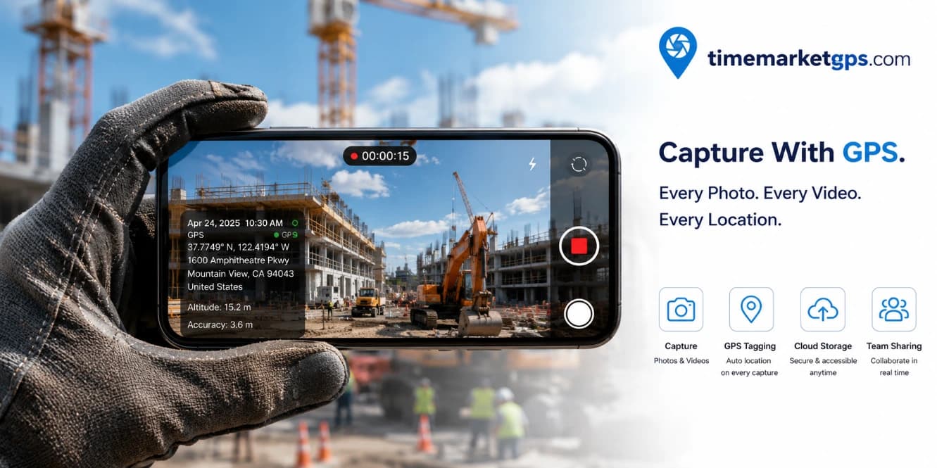
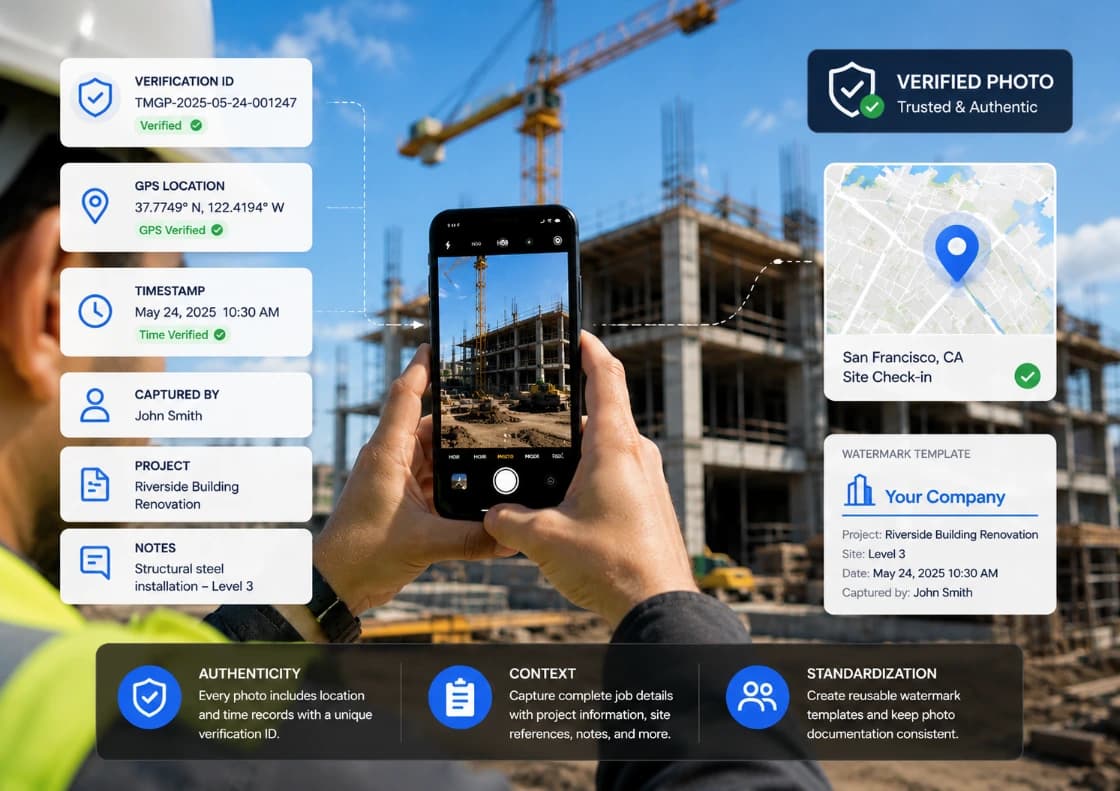
Capture Timestamped Proof You Can Trust
Authenticity: Every photo includes location and time records with a unique verification
ID for trusted field documentation.
Context: Capture complete job details with project information, site references, notes,
and supporting records
Standardization: Create reusable watermark templates and keep photo documentation consistent across your team
Work More Efficiently in the Field
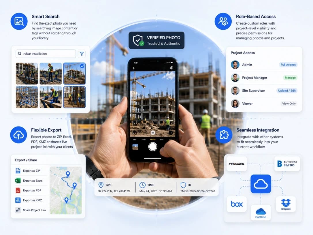
Smart Search
Find photos instantly using image details, project data, locations, or custom tags — no endless scrolling.
Controlled Access
Assign team roles with project-level access and permission settings for photos and documentation.
Flexible Delivery
Export records as ZIP, Excel, PDF, or KMZ, or share live project access with clients and stakeholders.
Connected Workflow
Connect with existing tools and keep photo documentation aligned with your current operations.
The Future of Intelligent Field Tracking.
Trusted by global teams to streamline operations and enhance workforce accountability. Elevate your performance with TimeMarkerGPS.


Share and Export Your Way

Link Sharing
Guest Access
Share project visibility instantly with guests — no account or setup required.
Adaptive Views
Switch between Gallery, Photo Sheet, and Map views to review work the way you need.
Live Updates
See new captures and field activity in real time as work progresses.
Bulk Export
Download multiple photos at once or export project records to PDF, KMZ, Excel, and more.
Connect Site with Office in 3 Steps
No training required. Start saving time today.
/01
Create Your Workspace
Set up your workspace and create your first project. Start free — no credit card required.
/02
Invite Your Team
Add team members instantly using email, share links, or SMS invitations.
/03
Capture on Site
Take photos in the field and sync them automatically to your workspace. Office teams can review updates instantly from the web dashboard.
Built for Real Field Work
Everything you need to capture, organize, and deliver field documentation in one place.
Easy to Adopt
Start quickly with a simple workflow designed for field teams. No complex setup or lengthy onboarding required.
Flexible for Every Team
Scale projects and team access based on your operational needs with flexible workspace management.
Works Anywhere
Capture photos, location records, and notes even without a connection. Everything syncs automatically once you’re back online.
Built for Teams Across Every Project
Support field work, project coordination, and stakeholder visibility from one shared workspace.
Field Teams
Capture site photos with location records, timestamps, and notes attached automatically. Organize uploads into the right project and continue documenting even when offline.
Project Managers
Monitor progress without collecting files manually. Review photos by project, location, or team, generate reports, and share project updates in real time.
Clients and Stakeholders
Follow project activity through organized galleries and structured reports. Access reliable visual records to review progress and stay aligned on milestones.
The Future of Intelligent Field Tracking.
Trusted by global teams to streamline operations and enhance workforce accountability. Elevate your performance with TimeMarkerGPS.